Terrain Buffer
GUI component
High-level terrain meshes make use of a shared terrain buffer, which provides common resources and functionality. This includes the shared mesh buffer, terrain data caching, terrain texture management and GPU resources for one or more graphics contexts.
The Terrain Buffer GUI component can be used to inspect the runtime aspects of a shared terrain buffer.
See the TerrainBufferGui API for more detail.
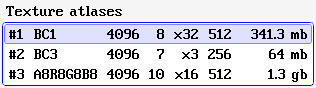
The terrain buffer may hold zero or more texture atlases, which are shown in this list. The columns have the following meaning (from left to right):
-
Ordinal number
-
Texture format name
-
Texture width / height
-
Mipmap level count
-
Array slice count
-
Tile size
-
Estimated size in GPU memory
Additional information is displayed for the currently selected row.
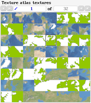
The toolbar is used to select a texture in the current texture atlas. The content of the selected texture is displayed below. A tile in a texture atlas may use sRGB conversion or not. The selected texture is rendered without sRGB conversion, which will make sRGB tiles appear brighter.
Individual tiles can be selected by clicking into the texture. More information about the clicked tile is shown below.
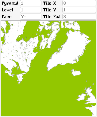
The header provides information that can be used to indentify the shown texture tile: the pyramid ID (as used in the code) and the pyramid tile coordinates (cubemap face, level, XY coordinates)
The tile pad gives the amount of data that has been 'borrowed' from neighbouring pyramid tiles, in order to avoid texture sampling artifacts.