Terrain Layer List
GUI component
High-level terrain meshes have a stack of user-definable layers which defines the texture of the terrain surface.
The Terrain Layer List GUI component shows the layer stack of the current terrain mesh and allows the user to modify some runtime settings.
See the TerrainLayer API for details.
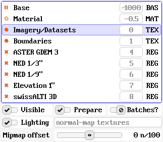
Each row in the layer list represents a layer of the terrain mesh. The columns show the following information:
-
Layer state (icon)
The 'pause' icon indicates that the layer is not visible, because it is occluded by the layers on top of it.
The 'circle' icon indicates that the layer is potentially visible but has no content.
The 'bullet' icon means that the layer content is visible.
The 'cross' icon means that the layer has been hidden explicitly.
-
Layer name
The human-readable name of the terrain layer.
-
Sort index (number)
The layer sort index defines the order in which layers are rendered: lower numbers are painted first, bigger numbers afterwards.
-
Layer type
There are four different layer types:
BAS : base terrain showing per-vertex data
MAT : material-based texturing
TEX : unique texturing with atlases
REG : overlay for available data regions
To modify the runtime settings of a terrain layer, first select it in the list and then use the user interface controls below.
Visible
The Visible checkbox can be used to toggle the visible state of a terrain layer. Layer occlusion is determined from visible layers on top.
Prepare
The Prepare checkbox can be used to trigger content preparation of the layer while it is not visible. Without preparation, the content will be built incrementally after the layer has become visible again.
Batches?
Terrain layers are rendered by splitting the terrain mesh into chunks and generating a render batch for each one. Use the Batches? checkbox to show or hide an overlay that uses colors to indicate render batches.
Lighting
The Lighting checkbox enables or disabled lighting the the terrain layer. Lighting computations (including shadow-mapping) are performed if at least one visible layer has lighting enabled.
The field indicates whether per-vertex normal vectors or normal-map textures are used for lighting.